WHAT WOULD A BIKEABLE, WALKABLE FISHKILL AVENUE LOOK LIKE?

Here is a vision for bike lanes on Fishkill Avenue.

Is there enough room for bike lanes on Fishkill Ave? Yes.
One concern that we have heard is about whether there is enough room for bikes, pedestrians and cars on Fishkill Avenue.

The images shown on this page show that in fact there is ample room to transform Fishkill Avenue into a “complete street” between Blackburn Avenue and the Fishkill Town line. That is, room enough for buffered bike lanes in two directions, sidewalks on both sides of the street, and two drive lanes big enough for trucks.

This first image is a map showing the Fishkill Avenue Zone, outlined in dashed cyan. The red keys show locations where we took measurements. Those measurements were used to generate drawings of roadway sections at 12 locations along the length of Fishkill Avenue. Several of those sections are shown below.

SECTION BB: JUST NORTH OF HANNAH LANE
The wall shown on the right is an existing masonry wall at this location.

There is an additional 4 1/2’ of space between a proposed 5’ sidewalk and the existing wa

Note the location of the proposed curb on the left side of the drawing. These section drawings assume that the new curb and sidewalk that is part of the 2024-2025 Fishkill Avenue roadway work will be located in approximately the same location of the existing curb, shown in the lower part of the drawings.

Here is a street view image at this location.

SECTION CC: AT CERVONE’S AUTOBODY
Note that there is 4 1/2’ between the sidewalk and the existing building at this location.

There is 4 1/2” between our proposed roadway and an existing building at this location.

Here is a street view image at this location.

SECTION GG: AT DALLIS PLACE
In the portion of Fishkill Avenue near Dallis Place, there is a slope between the existing roadway and the abandoned rail line where the Beacon Hopewell Rail Trail will be built.

Even at this location, there is plenty of room for bike lanes and sidewalks. For a very short distance, a small retaining wall may be required. With views of Fishkill creek, this would be a scenic section of Fishkill Avenue.

Further study will of course be required. You can see the approximate elevation drop between the sidewalk and the slope on the right side of this section drawing.

Here is a street view image at this location.

SECTION JJ: AT LANKS AUTOMOTIVE
Here is another example showing the roadway at an existing building. Note that there is room for a 5’ sidewalk between the buffered bike lane and the building.

In the future, new buildings constructed in the FA Zone can plan to leave additional space between the roadway and the building facade to leave room for plantings and other streetscape amenities.

On all of these drawings, the dashed line showing the Highway Boundary indicates the border between the public right-of-way and private parcels.

Here is a street view image at this location.

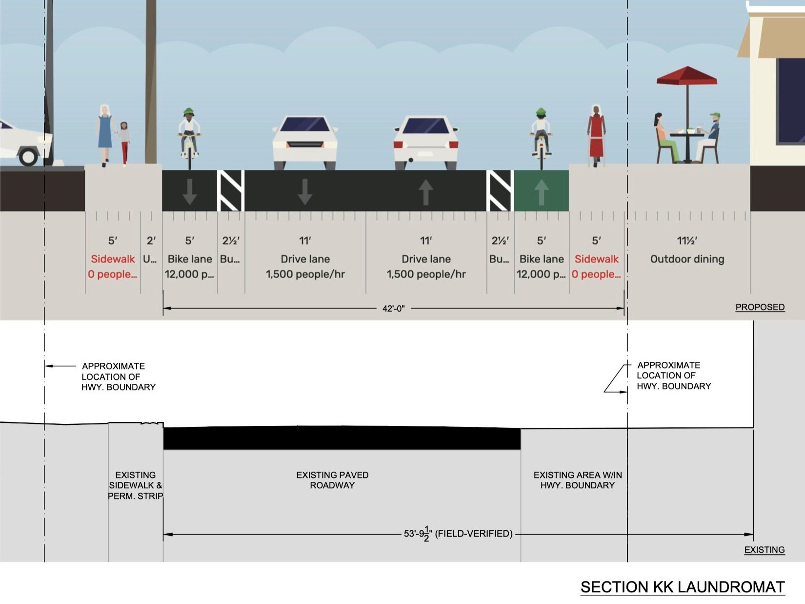
SECTION KK: AT LAUNDROMAT
At the laundromat close to the intersection of Townsend St., there is over 11’ of space between proposed sidewalk in this drawing and the laundromat building. This space could either be used for a wider sidewalk in this section, or as noted above, for plantings or other street amenities such as bike racks.

Here is a street view image at this location.

SECTION LL: AT CAR WASH
This drawing shows a condition where there is not enough room for a full 5’ sidewalk on the right hand side because the car wash structure is only 41’ from the curb on the opposite side. However, it’s important to note that this is only true for one corner of the structure, requiring reducing the sidewalk down to 4’ for a very short section.

As you walk around Beacon, you will notice many instances of sidewalks narrowing because an older building is close to the roadway.

Here is a street view image at this location.